
CUTTING edge technology can now show investors what Widnes waterfront will look like - in the future.
Click here for a 3d virtual reality look at the new plans
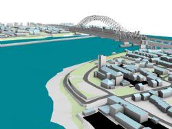
Space age animation - which gave World readers the chance to fly' over the iconic £500m Mersey Gateway - has been used to create a trailblazing 3D map of the town in years to come.
( Click here to watch colour animation of the fly over.)
"It is very accurate and will show investors exactly how their developments could fit in with our new ice rink, bowling alley and cinemas and where the new bridge will come in," said Cllr Rob Polhill, executive board member for development.
"As more and more development is happening, Haltonians will want to know how the buildings are going to look and fit into the existing town."
Laser and stereo aerial photography has been used to capture every road, junction, building and pavement earmarked to convert a former Victorian wasteland into a riverside leisure, business and recreational park.
Tony Tickle, of T3D, who designed the virtual map, said: "It's often difficult for people to fully appreciate the impact that a building will have on its surroundings from an architectural plan or scale model.
"What our system allows people to do is view it as if it were there. You can walk around a building at ground level, see how it will affect your home or business and fly over the building to see how it in its wider context.
"To map and render a 14 sq km area has been a massive undertaking.
"Nothing like this has ever been done before, it is truly a world first."
See it for yourself on our website www.runcornandwidnesworld.co.uk


Comments: Our rules
We want our comments to be a lively and valuable part of our community - a place where readers can debate and engage with the most important local issues. The ability to comment on our stories is a privilege, not a right, however, and that privilege may be withdrawn if it is abused or misused.
Please report any comments that break our rules.
Read the rules hereComments are closed on this article